Description
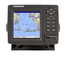
The IntelliMap® 480 is a new world-class, stand-alone Eagle® GPS+WAAS mapping system. It’s 480 x 480 high-resolution display provides fantastic mapping detail. And the IntelliMap® 480 is so smart, it displays MapCreate, Navionics, and HotMaps
Features of the Intellimap 480
Display:
- 5″ (12.7 cm) diagonal screen
- Film SuperTwist LCD
- High-definition 480×480 resolution
- Amber LED backlit screen and keypad
- 16-level grayscale
GPS+WAAS:
- 12-parallel channel GPS+WAAS reception with fast satellite lock-ons, precise tracking, and position updates every second with the external EGC-12W receiver
- Selectable on/off WAAS reception for enhanced position accuracy to 3 m (under 10 ft) at select locations
- Digitally record/play GPS trip details and display custom mapping with optional, reusable compact Multi-Media Cards (MMC) or Secure Digital (SD) memory cards. One waterproof slot for instantly-expandable memory using a single 8MB-512MB card
- All-new, built-in Eagle® background map with enhanced continental U.S. and Hawaii detail including nav aids
- High-speed screen updates
- Optional MapCreate™ Accessories Pack with MapCreate™ CD software that:
- Lets you create unlimited, custom, detailed maps on MMC or SD memory cards
- Includes unique, searchable database of streets, addresses, and over 700,000 Point-of-Interest (POI) to easily find/identify marinas, restaurants, airports, emergency services, and more
- Saves up to 1,000 waypoints, 1,000 event markers, and 100 routes (up to 100 waypoints/route)
- 100 savable plot trails with up to 10,000 points per trail
- 42 graphic icons to mark your favorite spots
- 38 map zoom ranges – from 0.04 to 4,000 miles – with easy zoom-in/out control
- Selectable on/off GPS alarms: Off Course, Arrival, and Anchor
- Compatible with optional plug-and-play Lowrance FreedomMaps™, Fishing Hot Spots® Elite, LakeMaster® Pro Maps, and Navionics® electronic charts on MMC/SD cards
Performance:
- Internal back-up memory keeps stored GPS data and settings safe and accessible for years
- Completely sealed and waterproof, even for use in harsh saltwater environments
- Full one-year warranty


Reviews
There are no reviews yet.